Mt. Katahdin via the Knife Edge
July 22, 1995
Hikers: "Team Tester:" Matthew Reagan, Randy Weinstein, Joanna
Dinaro, Brian Phenix, Phil Marrone, Matthew DiPippo, and friends.
This was my first big New England mountain climb. Quite a place to
start, don't you think?
 "Team Tester" plus many friends arrived at the south
gate of Baxter State Park at about 5:30am after a night in one of
Millinocket's fine lodging establishments. The early start time was
necessary due the the limited number of cars allowed into the inner
parking lots each day. We had a tough ten mile hike as it is, so
walking into the park was not an option! We began our hike from the
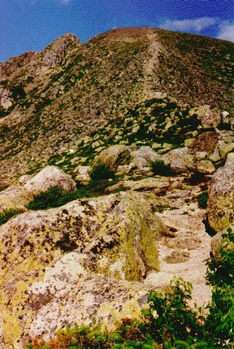
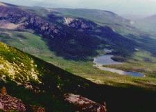
Roaring Brook campground and ascended via the Helon Taylor trail. The
trail climbs moderately up a minor wooded peak, descends into a minor
col, and then heads steeply up the ridge towards Pamola Peak. As we
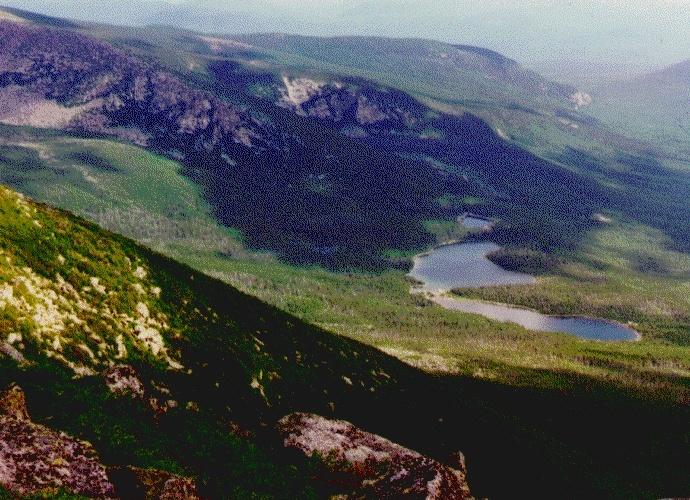
reached treeline, magnificent views into the valley below opened up to
the north (first photo--click for full sized version).
"Team Tester" plus many friends arrived at the south
gate of Baxter State Park at about 5:30am after a night in one of
Millinocket's fine lodging establishments. The early start time was
necessary due the the limited number of cars allowed into the inner
parking lots each day. We had a tough ten mile hike as it is, so
walking into the park was not an option! We began our hike from the
Roaring Brook campground and ascended via the Helon Taylor trail. The
trail climbs moderately up a minor wooded peak, descends into a minor
col, and then heads steeply up the ridge towards Pamola Peak. As we
reached treeline, magnificent views into the valley below opened up to
the north (first photo--click for full sized version).
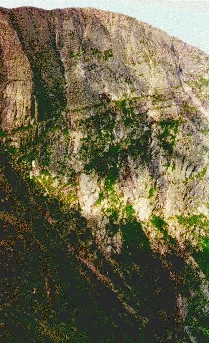
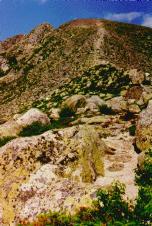 The trail then began a steep
ascent straight up Pamola (second photo, left), with full exposure
and views north toward the Maine wilderness, south toward the
Penobscot, and east to the coast. Fortunately, the weather was
perfect, with plenty of sun and only a light breeze, allowing us to
seriously consider a crossing of the knife edge. From the summit of
Pamola Peak, we stood at the brink of the great South Basin of
Katahdin, with views across the giant cirque to Baxter Peak (third
photo, right), the main summit, and the steep cliffs that form the
Chimney and the northern wall of the Knife Edge.
The trail then began a steep
ascent straight up Pamola (second photo, left), with full exposure
and views north toward the Maine wilderness, south toward the
Penobscot, and east to the coast. Fortunately, the weather was
perfect, with plenty of sun and only a light breeze, allowing us to
seriously consider a crossing of the knife edge. From the summit of
Pamola Peak, we stood at the brink of the great South Basin of
Katahdin, with views across the giant cirque to Baxter Peak (third
photo, right), the main summit, and the steep cliffs that form the
Chimney and the northern wall of the Knife Edge.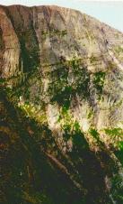
After a brief rest on the Pamola summit, we followed the trail south
and west toward the Chimney. This formation is a narrow cleft in the
ridge-top capping a steep, chute-like gully that plunges down into the
basin. The trail passes down into and then up out of this cleft, with
only natural handholds available. The view into the Chimney cleft
itself is spectacular and somewhat frightening considering the
exposure.
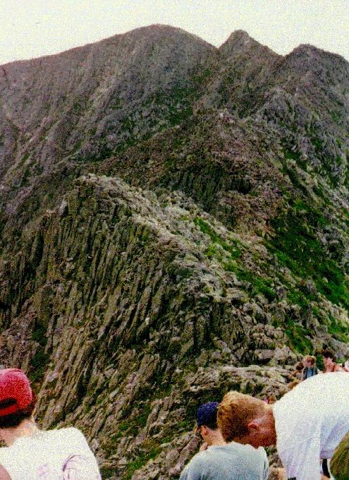
Once past the Chimney, we headed out onto the Knife Edge itself. The
trail snakes along the north side of the ridge with just enough
footing for single-file passage, and then attains the ridge top with
awesome views and ridiculous exposure (fourth photo, left).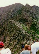 O At some points, the trail is
only two to three feet wide, and is "paved" with loose, often tilted,
rock slabs. A steep, scrub-covered slope heads down to the south (for
several thousand feet), and ledges and hanging cliffs line the basin
to the north. Don't try this in fog, ice, windy weather, or with
people who are afraid of heights.
O At some points, the trail is
only two to three feet wide, and is "paved" with loose, often tilted,
rock slabs. A steep, scrub-covered slope heads down to the south (for
several thousand feet), and ledges and hanging cliffs line the basin
to the north. Don't try this in fog, ice, windy weather, or with
people who are afraid of heights.
We followed the ridge west for about one mile and two hours, and soon
approached the broader shoulder of Baxter Peak. Footing in this area
is less certain due to smaller, looser rock, but without the cliff on
the right, it's not much of a problem. Several minor summits must be
crossed along this section of the ridge, and we gained the last bit of
vertical to reach the summit cone.
 On the main summit, the trail meets up with the
northern end of the Appalachian Trail at a wooden marker and metal
plaque (fifth photo, right). An enormous summit cairn adds twenty feet to
the height (5260' as it is). We spent an hour on the summit (which
was surprisingly crowded for such an inaccessible place) enjoying the
360' views and a well-earned lunch.
On the main summit, the trail meets up with the
northern end of the Appalachian Trail at a wooden marker and metal
plaque (fifth photo, right). An enormous summit cairn adds twenty feet to
the height (5260' as it is). We spent an hour on the summit (which
was surprisingly crowded for such an inaccessible place) enjoying the
360' views and a well-earned lunch.
From the summit, we headed south and west along the A.T. itself, onto
the broad alpine plateau that forms the southern foundation of the
peak. At the low point of the col, we turned north and descended
rapidly down the Saddle Trail, a steep slidepath of sand and loose
rock that drops into the scrub along the lip of the basin. 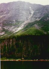 We had one close call at this point, as one climber
lost her footing on a loose rock and took a ten foot header into the
scrub. A well-placed backpack cushioned the fall and helped us avoid
a long, long, long evacuation attempt. At the bottom of the slide, we
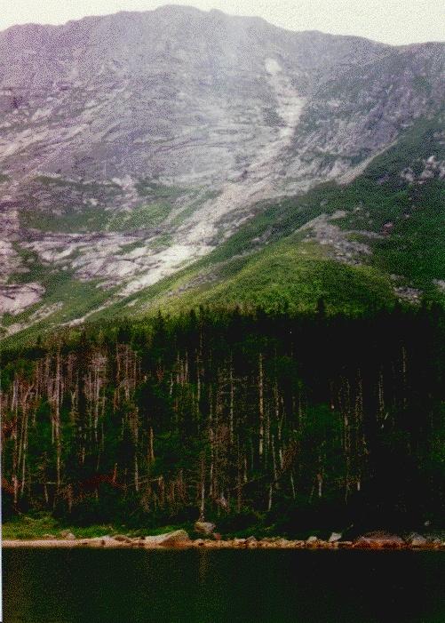
entered an airy section of pine forest along the floor of the basin,
and about a mile below reached the campground at Chimney Pond. The
views across the pond to the Chimney and the Knife Edge cliffs were
remarkable (last photo, left) and unlike anything I've seen in the
Northeast.
We had one close call at this point, as one climber
lost her footing on a loose rock and took a ten foot header into the
scrub. A well-placed backpack cushioned the fall and helped us avoid
a long, long, long evacuation attempt. At the bottom of the slide, we
entered an airy section of pine forest along the floor of the basin,
and about a mile below reached the campground at Chimney Pond. The
views across the pond to the Chimney and the Knife Edge cliffs were
remarkable (last photo, left) and unlike anything I've seen in the
Northeast.
As wonderful as this spot was (if you ever camp in Baxter, I highly
recommend it), we still had nearly four miles of hiking to get back to
Roaring Brook. The trail from here was a moderately graded but rocky
hike through pine woods, birch woods, and finally hardwood forest.
The last mile followed the bank of the brook itself, although few of
us clearly remember exactly what that part of the hike was like.
Total time: 13 hours. Oh, my.
photos by Matthew Reagan
Back to Outdoor
Adventures
 "Team Tester" plus many friends arrived at the south
gate of Baxter State Park at about 5:30am after a night in one of
Millinocket's fine lodging establishments. The early start time was
necessary due the the limited number of cars allowed into the inner
parking lots each day. We had a tough ten mile hike as it is, so
walking into the park was not an option! We began our hike from the
Roaring Brook campground and ascended via the Helon Taylor trail. The
trail climbs moderately up a minor wooded peak, descends into a minor
col, and then heads steeply up the ridge towards Pamola Peak. As we
reached treeline, magnificent views into the valley below opened up to
the north (first photo--click for full sized version).
"Team Tester" plus many friends arrived at the south
gate of Baxter State Park at about 5:30am after a night in one of
Millinocket's fine lodging establishments. The early start time was
necessary due the the limited number of cars allowed into the inner
parking lots each day. We had a tough ten mile hike as it is, so
walking into the park was not an option! We began our hike from the
Roaring Brook campground and ascended via the Helon Taylor trail. The
trail climbs moderately up a minor wooded peak, descends into a minor
col, and then heads steeply up the ridge towards Pamola Peak. As we
reached treeline, magnificent views into the valley below opened up to
the north (first photo--click for full sized version).