Zealand Notch, Zealand Falls, and Zealand Mtn.
June 1, 1997
Hikers: Matthew Reagan, Randy Weinstein
This was the first ski-free hike of "Summer" 1997, but as with our
attempts on Tuckerman, the weather did not cooperate. Although the
weather called for clearing skies throughout the day, we never saw the
sun. However, foul weather often makes for good hiking--if you have
the proper gear and enjoy having the whole trail to yourself.
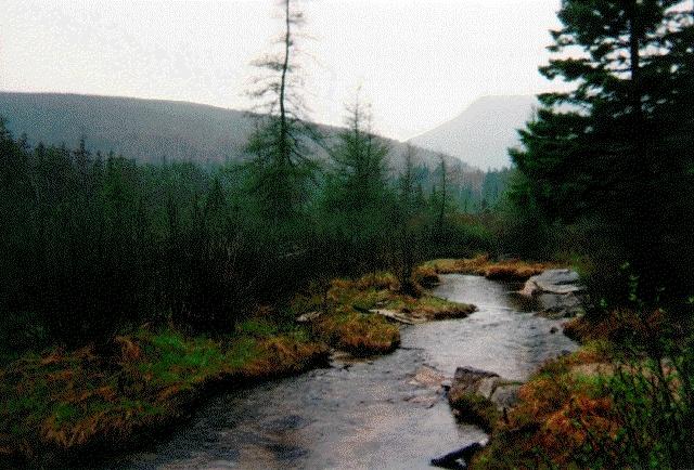
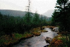 Our hike began at the end of Zealand River Road (five
miles in from 302). We hiked south along the Zealand River in a light
misty drizzle. The forest was quiet, and the views were still
beautiful through the mist. Here is a photo of the river and the
wilderness beyond from a boardwalk one mile from the trailhead (click
on the photos to see the full-size version). Considerable beaver
activity was evident, and at one rest stop we actually spotted one of
our rodent namesakes. It is worth noting that this area was once
referred to as "Death Valley," due to the extensive clear-cutting of
forest in the late 1800s and a series of severe fires in the early
1900s. The area has recovered nicely over the past seventy or so
years, and only the size of the trees and distribution of undergrowth
reveal the age. Even with the evident newness of the forest, the
distance from civilization makes for a very "wild" experience.
Our hike began at the end of Zealand River Road (five
miles in from 302). We hiked south along the Zealand River in a light
misty drizzle. The forest was quiet, and the views were still
beautiful through the mist. Here is a photo of the river and the
wilderness beyond from a boardwalk one mile from the trailhead (click
on the photos to see the full-size version). Considerable beaver
activity was evident, and at one rest stop we actually spotted one of
our rodent namesakes. It is worth noting that this area was once
referred to as "Death Valley," due to the extensive clear-cutting of
forest in the late 1800s and a series of severe fires in the early
1900s. The area has recovered nicely over the past seventy or so
years, and only the size of the trees and distribution of undergrowth
reveal the age. Even with the evident newness of the forest, the
distance from civilization makes for a very "wild" experience.
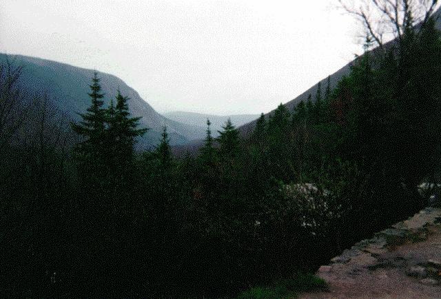
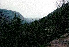 Our first destination was Zealand Falls Hut. Here is
a photo of Zealand Notch (the northern gateway into the Pemigewasset
Wilderness) from the front porch of the hut. The trace of white in
the trees is not snow (yet), but the foaming rapids above Zealand
Falls. We followed the Twinway trail uphill from there, and above the
hut encountered an unusually nasty water crossing. The normally
gentle stream feeding the falls was swollen by a combination of rain
and meltwater, and required clever use of logs, poles, and
long-jumping to cross. A few hundred feet above this crossing (around
3700'), we encountered snow. The trail was well packed near the
center, but as the snow got deeper the postholing got worse. We broke
through the forest onto the less-protected ridge at around 4000', and
were able to leave the snow behind for a while.
Our first destination was Zealand Falls Hut. Here is
a photo of Zealand Notch (the northern gateway into the Pemigewasset
Wilderness) from the front porch of the hut. The trace of white in
the trees is not snow (yet), but the foaming rapids above Zealand
Falls. We followed the Twinway trail uphill from there, and above the
hut encountered an unusually nasty water crossing. The normally
gentle stream feeding the falls was swollen by a combination of rain
and meltwater, and required clever use of logs, poles, and
long-jumping to cross. A few hundred feet above this crossing (around
3700'), we encountered snow. The trail was well packed near the
center, but as the snow got deeper the postholing got worse. We broke
through the forest onto the less-protected ridge at around 4000', and
were able to leave the snow behind for a while.
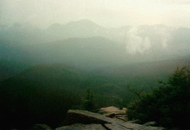
 Our reward for all this effort was the Zeacliff
lookout. The photo here shows the view to the south, with the hills
of the Pemigewasset Wilderness in the foreground and the jagged
boundary ridge of Mts. Carrigain and Hancock in the distance. It was
still drizzling lightly, but the sky had brightened considerably and a
little cold and damp weather wasn't able to spoil our appreciation of
the view.
Our reward for all this effort was the Zeacliff
lookout. The photo here shows the view to the south, with the hills
of the Pemigewasset Wilderness in the foreground and the jagged
boundary ridge of Mts. Carrigain and Hancock in the distance. It was
still drizzling lightly, but the sky had brightened considerably and a
little cold and damp weather wasn't able to spoil our appreciation of
the view.
From here, we followed the Twinway eastward along the ridge. On the
exposed rock ledges we found little snow but plenty of mud, as well as
a large pile of moose droppings (just like the ones they sell as
jewelry at Kittery Trading Post--but free!). As we approached the
summit cone of Zealand Mtn. the trail went back into the woods--and
therefore back into the deep snow. The ridge was heavily wooded and
wrapped in dark rain clouds, but we pressed on. Our reward was a
cold, wet lunch in the snow somewhere near, but probably not on, the
summit. (Note: I went back in 1999 and found out, sadly, that we'd
missed it completely. The top was still a mile further down the trail
past numerous other false summits.) We started back as quickly as
possible, and were treated to brightening skies as we re-crossed the
ridge, with hazy views of the Pemi, the snow-covered Presidentials,
and Franconia Ridge. The warm, dry, cozy hut was a welcome sight on
the way down.
photos by Matthew Reagan
Back to Outdoor
Adventures
 Our hike began at the end of Zealand River Road (five
miles in from 302). We hiked south along the Zealand River in a light
misty drizzle. The forest was quiet, and the views were still
beautiful through the mist. Here is a photo of the river and the
wilderness beyond from a boardwalk one mile from the trailhead (click
on the photos to see the full-size version). Considerable beaver
activity was evident, and at one rest stop we actually spotted one of
our rodent namesakes. It is worth noting that this area was once
referred to as "Death Valley," due to the extensive clear-cutting of
forest in the late 1800s and a series of severe fires in the early
1900s. The area has recovered nicely over the past seventy or so
years, and only the size of the trees and distribution of undergrowth
reveal the age. Even with the evident newness of the forest, the
distance from civilization makes for a very "wild" experience.
Our hike began at the end of Zealand River Road (five
miles in from 302). We hiked south along the Zealand River in a light
misty drizzle. The forest was quiet, and the views were still
beautiful through the mist. Here is a photo of the river and the
wilderness beyond from a boardwalk one mile from the trailhead (click
on the photos to see the full-size version). Considerable beaver
activity was evident, and at one rest stop we actually spotted one of
our rodent namesakes. It is worth noting that this area was once
referred to as "Death Valley," due to the extensive clear-cutting of
forest in the late 1800s and a series of severe fires in the early
1900s. The area has recovered nicely over the past seventy or so
years, and only the size of the trees and distribution of undergrowth
reveal the age. Even with the evident newness of the forest, the
distance from civilization makes for a very "wild" experience.