Chimney Tops, Great Smoky Mountains National Park
December 13, 1997
This was a solo hike, but thanks to the mild climate of East Tennessee
and the vigilance of the National Park administration it wasn't much
of an adventure. Nothing wrong with a few nice views, though.
After spending two long days giving talks and getting feedback from
the fine folks at Oak Ridge National Laboratory, I set off eastward to
kill time over the weekend (needed a Saturday night stay to get that
cheap plane ticket!). The approach to the Smokies was impressive in a
sick sort of way, thanks to the shitkicker glitz of Pigeon Forge and
the Tyrolian-Hillybilly charm of Gatlinburg. I'm glad I wasn't
driving my own car, with its Massachusetts plates and Darwin-fish, especially after
hearing some local radio host call for the execution (by burning, of
course) of atheists, theoretical scientists, and non-Christian college
professors.
But, at least the scenery was nice. After a brief visit to the
Gatlinburg visitor center of the GSMNP to purchase a trail map, I
headed off and up into the park.
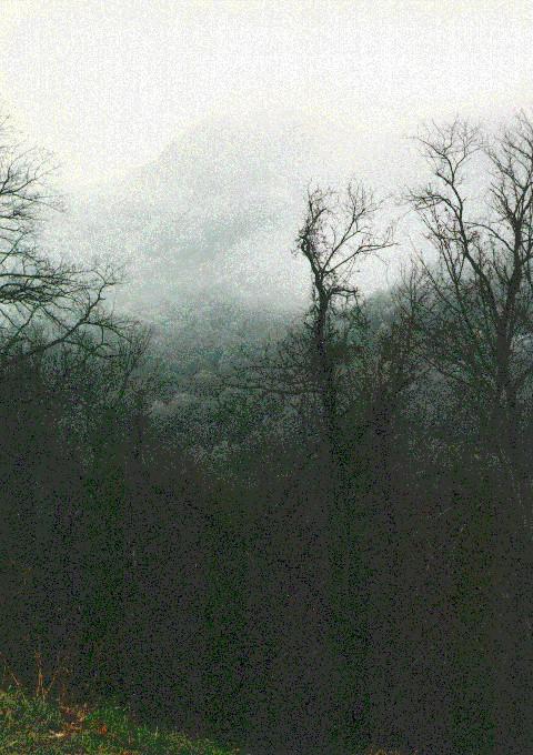
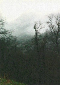 The approach was beautiful. Unlike the National
Forest in VT/NH/ME, this was a Park, and had the extra touch of
well-paved roads, well-marked trailheads, and well-groomed paths. As
the road twisted upward, I was greeted by wonderful images of fog and
rime-shrouded trees (click on the photos to see full-size versions).
Although it had been cold enough the night before to leave a little
frozen fog on trees in the valley, the temperatures were just above
freezing, even at 9am. The drive up was only spoiled by drivers
having trouble with the steep grades and sharp turns. Despite the
traffic, I managed to find a parking space at the Chimney Tops
trailhead and set off with what I'd normally use as early-fall
gear.
The approach was beautiful. Unlike the National
Forest in VT/NH/ME, this was a Park, and had the extra touch of
well-paved roads, well-marked trailheads, and well-groomed paths. As
the road twisted upward, I was greeted by wonderful images of fog and
rime-shrouded trees (click on the photos to see full-size versions).
Although it had been cold enough the night before to leave a little
frozen fog on trees in the valley, the temperatures were just above
freezing, even at 9am. The drive up was only spoiled by drivers
having trouble with the steep grades and sharp turns. Despite the
traffic, I managed to find a parking space at the Chimney Tops
trailhead and set off with what I'd normally use as early-fall
gear.
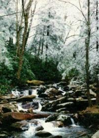 The well-trodden and well-groomed trail followed a
gorgeous stream through rime-encrusted woods. Several signs noted the
2 mi, 2000' climb, and another set included repetative warnings not to
fall off cliffs. Apparently this is a serious problem.
The well-trodden and well-groomed trail followed a
gorgeous stream through rime-encrusted woods. Several signs noted the
2 mi, 2000' climb, and another set included repetative warnings not to
fall off cliffs. Apparently this is a serious problem.
The path climbed gently along the main stream, then turned right and
up at the 1.3mi mark. The grade increased substantially, but the
groomed dirt path was still far easier than the typical rock-strewn
trails of NH. A smaller stream gurgled along the right side for a few
thousand feet, then was lost as the trail rose in graded switchbacks.
A little ice actually made for tricky footing here and there, despite
the park's best efforts to practically pave the way to the viewpoint.
The last hundred yards mounted the crest of the ridge, opening up to
views east and west at the base of the first Chimney.
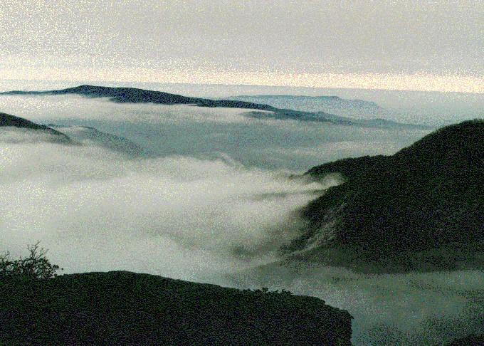
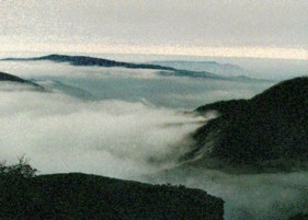 Here is the view from the base of the first Chimney,
looking west towards Gatlinburg. The early morning fog had yet to
burn off, giving a view of not only the famous blue haze of the
Smokies, but of the tops of the low clouds in the valleys to the West.
To the east, there was little fog, but instead wide swaths of white,
rime-covered trees rising is towards the 6000' crest of the Smokies.
Well worth a 2 mile, walk, I'd say.
Here is the view from the base of the first Chimney,
looking west towards Gatlinburg. The early morning fog had yet to
burn off, giving a view of not only the famous blue haze of the
Smokies, but of the tops of the low clouds in the valleys to the West.
To the east, there was little fog, but instead wide swaths of white,
rime-covered trees rising is towards the 6000' crest of the Smokies.
Well worth a 2 mile, walk, I'd say.
At the first viewpoint stood a sign warning against travelling "past
the Chimneys," since it seems that over a dozen people had fallen off
over the past decade. However, a trail led north around the base of
the first Chimney, so I figured that there must be something
worth seeing in that direction. Some mud and scrub kept the tourists
out, though, and I was able to find a unmarked but unmistakable
pathway up the east face of the second Chimney.
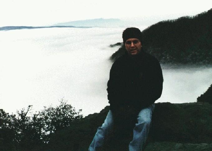
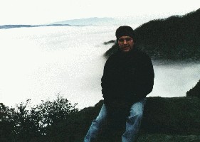 This was more like it--none of the trampled brush and
food wrappers of the main viewpoint, plus an extra hundred feet or so
of vertical (4800', according to the map). A chilly wind out of the
valley to the west made it feel more like home (NH in the early fall,
that is!). A steep drop to the west increased the sense of exposure,
while the heavily-trafficked road down below put the 2000' drop in
perspective. To the north, the ridge continued a bit to a third,
smaller chimney, but I figured that this formation was the one
mentioned in the signs and decided to follow the rules and stay
away.
This was more like it--none of the trampled brush and
food wrappers of the main viewpoint, plus an extra hundred feet or so
of vertical (4800', according to the map). A chilly wind out of the
valley to the west made it feel more like home (NH in the early fall,
that is!). A steep drop to the west increased the sense of exposure,
while the heavily-trafficked road down below put the 2000' drop in
perspective. To the north, the ridge continued a bit to a third,
smaller chimney, but I figured that this formation was the one
mentioned in the signs and decided to follow the rules and stay
away.
The hike down was uneventful, although it was nice to stop and chat
with the seriously winded folks plodding upward. The guy wheezing
"How much farther?!?" within sight of the parking area probably didn't
make it.
With this warmup hike under my belt and a cozy night at a Gatlinburg
Econolodge to give me strength, I spent the next day hiking up the
(closed!) road to Clingman's Dome, the highest point on the AT.
Although I wouldn't recommend the 15 mile round-trip plod to anyone
without excellent pavement-walking stamina, the quiet, deserted summit
complex was quite interesting. The view was fantastic, of course.
photos by Matthew Reagan
Back to Outdoor
Adventures
 The approach was beautiful. Unlike the National
Forest in VT/NH/ME, this was a Park, and had the extra touch of
well-paved roads, well-marked trailheads, and well-groomed paths. As
the road twisted upward, I was greeted by wonderful images of fog and
rime-shrouded trees (click on the photos to see full-size versions).
Although it had been cold enough the night before to leave a little
frozen fog on trees in the valley, the temperatures were just above
freezing, even at 9am. The drive up was only spoiled by drivers
having trouble with the steep grades and sharp turns. Despite the
traffic, I managed to find a parking space at the Chimney Tops
trailhead and set off with what I'd normally use as early-fall
gear.
The approach was beautiful. Unlike the National
Forest in VT/NH/ME, this was a Park, and had the extra touch of
well-paved roads, well-marked trailheads, and well-groomed paths. As
the road twisted upward, I was greeted by wonderful images of fog and
rime-shrouded trees (click on the photos to see full-size versions).
Although it had been cold enough the night before to leave a little
frozen fog on trees in the valley, the temperatures were just above
freezing, even at 9am. The drive up was only spoiled by drivers
having trouble with the steep grades and sharp turns. Despite the
traffic, I managed to find a parking space at the Chimney Tops
trailhead and set off with what I'd normally use as early-fall
gear.