Mt. Adams via King Ravine
September 29, 1996
Hikers: Matthew Reagan, Randy Weinstein
An ascent of Mt. Adams via King
Ravine (Air Line to Short Line to King Ravine trail) is one of the
most strenuous day hikes I've ever experienced. From the Appalachia
parking area, the route winds up a moderately-graded but rocky trail
to the floor of the ravine. The usual route involves several trail
junctions, using the Air Line and Short Line trails to connect to the
King Ravine trail just below Mossy Fall. A few nice cascades provide
sightseeing stops along the way. Once in the ravine, however, things
become more difficult.
 The trail into the ravine
is well described at the White Mountains
Server, with nice photos of
the upper ravine floor and headwall. The trail passes over, around,
and sometimes under those large boulders! The ravine is filled with
such rocks, some human-sized, some car-sized, some house-sized. A
good bit of scrambling and climbing is required to cross the ravine
floor, and all that effort doesn't gain you much altitude. Two side
paths branch off before you reach the headwall. One called the
"Subway" takes you through a few hundred yards of narrow boulder caves
(a narrow pack and a rope come in handy here). At the foot of the
headwall, the Ice Caves side path takes you through another series of
deep boulder caves beneath the shadow of the ravine. Snow and ice can
be found here year-round. Beyond this point the trail ascends
straight up the headwall, attaining the 5000' mark in less than a mile
of trail. The reward for this effort is a spectacular view of King
Ravine and Durand and Nowell Ridges, and a view of the rest of the
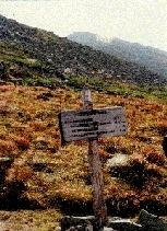
Presidentials once the plateau is reached. The first photo gives a
view of the alpine plateau just above the lip of the ravine, with
Mt. Jefferson in the background beyond the col and trail intersection
known as Thunderstorm Junction.
The trail into the ravine
is well described at the White Mountains
Server, with nice photos of
the upper ravine floor and headwall. The trail passes over, around,
and sometimes under those large boulders! The ravine is filled with
such rocks, some human-sized, some car-sized, some house-sized. A
good bit of scrambling and climbing is required to cross the ravine
floor, and all that effort doesn't gain you much altitude. Two side
paths branch off before you reach the headwall. One called the
"Subway" takes you through a few hundred yards of narrow boulder caves
(a narrow pack and a rope come in handy here). At the foot of the
headwall, the Ice Caves side path takes you through another series of
deep boulder caves beneath the shadow of the ravine. Snow and ice can
be found here year-round. Beyond this point the trail ascends
straight up the headwall, attaining the 5000' mark in less than a mile
of trail. The reward for this effort is a spectacular view of King
Ravine and Durand and Nowell Ridges, and a view of the rest of the
Presidentials once the plateau is reached. The first photo gives a
view of the alpine plateau just above the lip of the ravine, with
Mt. Jefferson in the background beyond the col and trail intersection
known as Thunderstorm Junction.
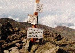 The last photo is my take on the familiar Mt. Adams
summit signpost (5798'). In the distance, a few clouds pass below the
edge of the plateau. Nowell Ridge heads away and down in the
distance. The weather this day was cool and breezy with occasional
clouds and drizzle, but we had a few clear breaks on the summit before
a larger rainstorm moved in. A planned side-trip to Madison Springs
Hut was cancelled as thunder was heard in the distance. The trip down
the knife-edge of Durand Ridge was spectacular as the thickening fog
reduced visibility to only the narrow path we were travelling.
The last photo is my take on the familiar Mt. Adams
summit signpost (5798'). In the distance, a few clouds pass below the
edge of the plateau. Nowell Ridge heads away and down in the
distance. The weather this day was cool and breezy with occasional
clouds and drizzle, but we had a few clear breaks on the summit before
a larger rainstorm moved in. A planned side-trip to Madison Springs
Hut was cancelled as thunder was heard in the distance. The trip down
the knife-edge of Durand Ridge was spectacular as the thickening fog
reduced visibility to only the narrow path we were travelling.
For our return trip we chose the easier and better-graded Air Line
trail down the remainder of Durand Ridge. The thunderstorms never
materialized, although we did experience some heavy showers just below
treeline. Of course, it was dry and sunny back at Appalachia.
Photos by Matthew Reagan
Back to Outdoor
Adventures
 The trail into the ravine
is well described at the White Mountains
Server, with nice photos of
the upper ravine floor and headwall. The trail passes over, around,
and sometimes under those large boulders! The ravine is filled with
such rocks, some human-sized, some car-sized, some house-sized. A
good bit of scrambling and climbing is required to cross the ravine
floor, and all that effort doesn't gain you much altitude. Two side
paths branch off before you reach the headwall. One called the
"Subway" takes you through a few hundred yards of narrow boulder caves
(a narrow pack and a rope come in handy here). At the foot of the
headwall, the Ice Caves side path takes you through another series of
deep boulder caves beneath the shadow of the ravine. Snow and ice can
be found here year-round. Beyond this point the trail ascends
straight up the headwall, attaining the 5000' mark in less than a mile
of trail. The reward for this effort is a spectacular view of King
Ravine and Durand and Nowell Ridges, and a view of the rest of the
Presidentials once the plateau is reached. The first photo gives a
view of the alpine plateau just above the lip of the ravine, with
Mt. Jefferson in the background beyond the col and trail intersection
known as Thunderstorm Junction.
The trail into the ravine
is well described at the White Mountains
Server, with nice photos of
the upper ravine floor and headwall. The trail passes over, around,
and sometimes under those large boulders! The ravine is filled with
such rocks, some human-sized, some car-sized, some house-sized. A
good bit of scrambling and climbing is required to cross the ravine
floor, and all that effort doesn't gain you much altitude. Two side
paths branch off before you reach the headwall. One called the
"Subway" takes you through a few hundred yards of narrow boulder caves
(a narrow pack and a rope come in handy here). At the foot of the
headwall, the Ice Caves side path takes you through another series of
deep boulder caves beneath the shadow of the ravine. Snow and ice can
be found here year-round. Beyond this point the trail ascends
straight up the headwall, attaining the 5000' mark in less than a mile
of trail. The reward for this effort is a spectacular view of King
Ravine and Durand and Nowell Ridges, and a view of the rest of the
Presidentials once the plateau is reached. The first photo gives a
view of the alpine plateau just above the lip of the ravine, with
Mt. Jefferson in the background beyond the col and trail intersection
known as Thunderstorm Junction.