
Summer '99 - Wyoming road trip
Arriving at the Denver airport seemed to presage three interesting weeks ahead. On the flight in, looking at the endless expanse of fluffy clouds, I spotted the unmistakeable anvil island sticking prominently avove the surrounding cloudscape. Of coures, I though. A classic thunderstorm. Cool. Soon it was left behind. As we descended into Denver, anther cloud just like it appeared much closer. The thunderstom was apperently about ready to move above the airport, just in time for our landing approach. Rain patterd on the cabin and the lightning struck all around as the pilot valiantly fought gusty turbulence(Ok, you could not really hear the rain, but the lightning and turbulence were there). Being an engineer from MIT, I knew that lightning could not harm plances, so I sat back relaxed...or could it. Hmm...
Anyway, Lisa found me wandering in the teepee-covered airport dazed with the altitude (over a mile high, remember) but happy nevertheless, and soon we were rolling on our way to the Rocky Mountain NP, and to the welcome party. Well, Lisa has her way of starting the vacation, and I was determined to go along, even though a party the last thing I expected at the beginning of a wilderness adventure. In the end I ended up meeting Lisa's really-hard-core mountaineer cousin Dan, as well as Brian, a RMNP trail crew guy with a great taste in music and an interesting photo collection - not to mention a cabin where we ended up crashing more than once. Untiting, Lisa and Brian heded off for a night hike, while I decided to let the crazy people wear themselves out and headed to sleep somewhere outside.I woke up on the grass of a hillside, with a beautiful view of the Diamond of Long's Peak, just inside the RMNP.
Lisa and I decided a while befor the trip that the first destination, a warm-up of sorts, would be Devil's Tower in northeastern Wyoming. After leading some solid 5.7 trad climbs on the east coast, I was confident that I could manage at least a few routes. The drive took us through the depressingly flat parts od wyomin in the Thunder Basin natinal grassland. Watching the rolling wills for hour on end, I was bored enough to try and photograph any not-flat object in sight. I even took up the boring job of driving for a while. The tower does in fact jut out of the middle of a plain. There is a small band of cliffs a few miles of to the north-west, but they are not mentioned in the guidebooks. Not surprising, given the competition.
Climbing the Tower
 It
is relatively easy to find a spot at the one of the two campgrounds
at Devil's Tower, especially if you arrive mind-day. There
is a KOA at the entrance, and a much cheaper but still nice campground
just inside the park. The campgound in the park does not
have showers, but those can be had at the KOA campground.
The park office is located at the parking lot on the west side
of the tower. You need to sign in and out if you plan to
climb the tower.
It
is relatively easy to find a spot at the one of the two campgrounds
at Devil's Tower, especially if you arrive mind-day. There
is a KOA at the entrance, and a much cheaper but still nice campground
just inside the park. The campgound in the park does not
have showers, but those can be had at the KOA campground.
The park office is located at the parking lot on the west side
of the tower. You need to sign in and out if you plan to
climb the tower. 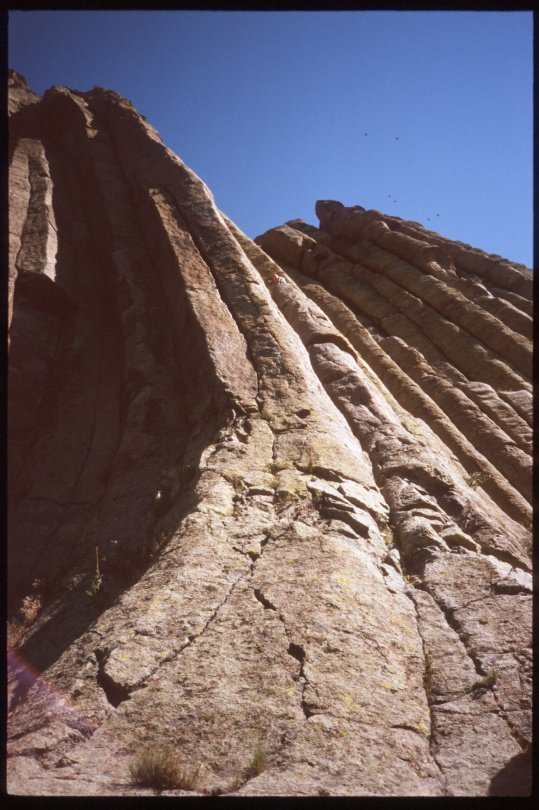 Most
of the easy climbs are on the south-eastern side, and get plenty
of sun in the morning. A paved walkway winds wound the entire
tower, providing easy access to all sides. Following the
instruction in the guidebook, we spurned the footpath, and instead
traversed on the slabs at the base of the tower to the base of
the first pitch of Durrance, our climb. Arriving there at
the end of some heavy duty scrambling (Lisa, why does this feel
like Class 5?), we arrived at the leaning column and found a party
heading up and another arriving, at the base of the second pitch.
Apparently they used a different guidebook, which adds another
pitch to our climb, a 150 ft 'endurance' section. That explained
the scrambling, I guess. Unfazed, we managed to thread our
way between the two parties, and continued up. Durrance is easy
and well protected, and draws about four times as many ascents
as all the other climbs on Devils Tower combined. The only
tricky thing about the clim are the offwidths, which require a
skill set (and gear) significantly different from the face climbing
which we have done out east. It can be done though, and
the route is fun, despite the crowding. For the matter,
the belay ledges leave time for socializing; Lisa picked up a
few lines from a climber from the group ahead of us.
Most
of the easy climbs are on the south-eastern side, and get plenty
of sun in the morning. A paved walkway winds wound the entire
tower, providing easy access to all sides. Following the
instruction in the guidebook, we spurned the footpath, and instead
traversed on the slabs at the base of the tower to the base of
the first pitch of Durrance, our climb. Arriving there at
the end of some heavy duty scrambling (Lisa, why does this feel
like Class 5?), we arrived at the leaning column and found a party
heading up and another arriving, at the base of the second pitch.
Apparently they used a different guidebook, which adds another
pitch to our climb, a 150 ft 'endurance' section. That explained
the scrambling, I guess. Unfazed, we managed to thread our
way between the two parties, and continued up. Durrance is easy
and well protected, and draws about four times as many ascents
as all the other climbs on Devils Tower combined. The only
tricky thing about the clim are the offwidths, which require a
skill set (and gear) significantly different from the face climbing
which we have done out east. It can be done though, and
the route is fun, despite the crowding. For the matter,
the belay ledges leave time for socializing; Lisa picked up a
few lines from a climber from the group ahead of us.
A climber's quest is not the top of the rock to which he clings,
but a far-off misty mountain-top, found only in his dreams.
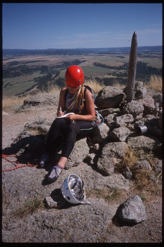
 She
picked it up in a few minutes, but it took me a dozen tries to
remember it. I still probably got it wrong.
She
picked it up in a few minutes, but it took me a dozen tries to
remember it. I still probably got it wrong.
The Durrance route ends in the Meadows, a huge ledge about two
thirds way up the tower. From here an exposed 4th class
chimney goes to the top of the tower. The going was easy,
but any fall would have been disastrous, so we roped up for this
last section.
The top of the tower is not impressive. Standing on top,
it feels like standing on the top of a grassy hill. It's
only close to the edges do the spectacualr drop-offs reveal themselves.
In addition, the top buzzes with nasty insects. Grass hoppers
living on the tower actually make a sound very similar to small
falling rocks bouncing off steep rock, making most climbers instinctively
cringe. I actually wish we had stayed to climb for another
day. But we were pressed for time, and instead decided to
meet here in three years or so, and do some of the harder climbs
- especially on the spectacular west face.

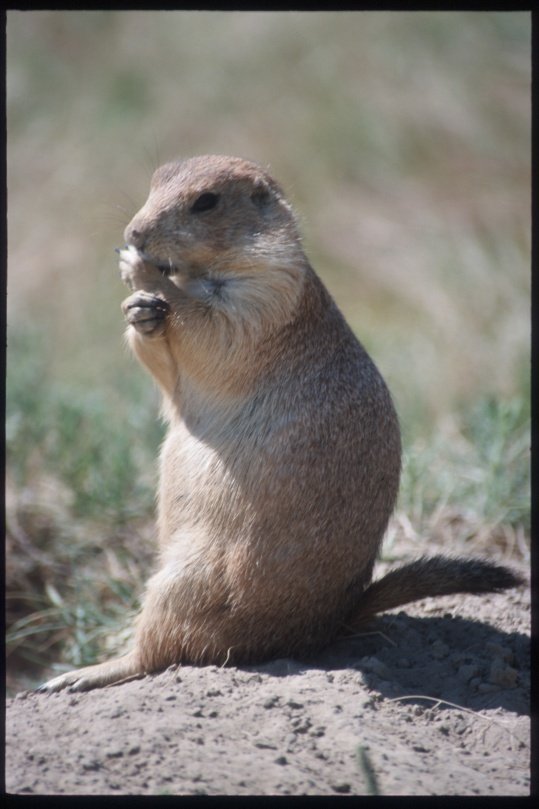
Prarie Dogs

 In
the evening shadow of the giant pillar, a multi level super-extended
familly of prarie dogs occupies a giant meadow next to the road.
Predicatable, the furry beasts are a mjor attraction to most visitors.
The Prarie dogs range from almost tame near the road, to completely
suspicious and wild only a hundered yards away from the traffic.
Photographing requeires some good light, and a good telephoto
lens (300 is nice), with a tripod. The best time, as with
most photographs, is in the morning or evening. However,
the Tower casts a shadow over the meadow in the evening, robbing
the photograph of some light.
In
the evening shadow of the giant pillar, a multi level super-extended
familly of prarie dogs occupies a giant meadow next to the road.
Predicatable, the furry beasts are a mjor attraction to most visitors.
The Prarie dogs range from almost tame near the road, to completely
suspicious and wild only a hundered yards away from the traffic.
Photographing requeires some good light, and a good telephoto
lens (300 is nice), with a tripod. The best time, as with
most photographs, is in the morning or evening. However,
the Tower casts a shadow over the meadow in the evening, robbing
the photograph of some light.
Below are a couple curious prarie dogs as well as bikers and Lisa
trying to capture the critters with wimpy point and shoot cameras.
Lisa I suspect was more effective than I since somehow she managed
to trick the rodents to come closer....

Bikers
We managed to arrive just in time for a biker rally, with thousands of motorcycles roaring along the streets of the little town near Devil's Tower (?). At the bars an in restaurants, the bikers discudded topics rangin from bike modification to weather in Ohio... A companionabel bunch os sorts, just liek climbers in a way. They like what they do in their free time and find companonship through their interest. A common topic of converstion is a good way to start friendships, breakign the ice. The local businesses were obliging to the bikers, making every effort to make them feel at home, up to an including flyiing a huge HD flag from the highest flagpole in town.


Bighorn Mountains
IN order to meet Steva and Cathy in Montana's Litte Rosewood
Canyon, we needed to drive through some rather scenic parts of
Wyoming. The bighorn mountains and the adjacent area of
Wyoming are not nearly as develped as the Rockies in Colorado,
and driving through is a true pleasure. We stopped at numerous
overlooks to take some photos (well, I was taking the photos,
using up my time credit with Lisa early on in the trip).
At a particularly interesting rock formation we decide to investigate
the possibilities for climbing. While bouldering on some
boulders at the bottom of the crag, my luck ran out. I pulled
of good sized block, which took of a good sized flap of skin off
my ankle. I enjoyed the beautiful vista while bandaging
the wound, and paid a visit to the local hospital in Sheridan,
where a young surgeon stitched me up, and assured us that my foot
would be abck in working order in a couple days, and that I should
not be sacrapping the three week road trip. Throughout the
stitching, Lisa peered over the doctor's shoulder, watching the
procedure with an immense amount of interest. I guess the
tendons in my ankle must have been a fascinating sight.
Interestingly, the doctor turned out to be an engineering student
that was unhappy with his job options, and decided to go to med
school so that he could live in such remote places like Sheridan.


Montana
East Rosebud Canyon
In Massachussets and New Hampshire, no ne would have bothered
to mark the kind of roads that lead to the East Rosebud canyon.
miles and miles barealy improved gravel or dirt roads lead to
goregeous valleys surrounded by inaccessible mountain peaks.
This is the still undeiscovered backroads U.S. like colorado
forty or fifty years ago.
We met Steve and Cathy, and promptly cancelled the plans to climb
Granite Peak. My foot was in no shape to carry a pack for sixteen
miles of rough terrain, and rainy weather moved in, meaning that
the higher elevations were likely have freezing rain or snow.
Not exactly the perfect weather to climb a remote peak that also
involved some technical climbing.


Billings
 After
the forced stop at the hsopital, we drove up to Billings and overnighted
in the world's first KOA. It was as expensive as all the
other KOA's, but at this point it was so late that we did not
care any more....
After
the forced stop at the hsopital, we drove up to Billings and overnighted
in the world's first KOA. It was as expensive as all the
other KOA's, but at this point it was so late that we did not
care any more....
Beartooth Highway (Rt 212)

 Beartooth
highway is yet another one of those depression-era projects that
was built using cheap labor and lots of deficit dollars.
And it is gorgeous. The sole puroose of the highway seems
to be to provide a scenic access route to Yellowstone NP, and
it does that one duty well. The roads cuts straight through
the Beartooth mountains, it's serpentines sinding thousands of
feet up to a pass at almost eleven tousand feet. The
views are gorggeous all through it, and given that my leg was
not in shape to carry me around, I spent more time taking photos.
Beartooth
highway is yet another one of those depression-era projects that
was built using cheap labor and lots of deficit dollars.
And it is gorgeous. The sole puroose of the highway seems
to be to provide a scenic access route to Yellowstone NP, and
it does that one duty well. The roads cuts straight through
the Beartooth mountains, it's serpentines sinding thousands of
feet up to a pass at almost eleven tousand feet. The
views are gorggeous all through it, and given that my leg was
not in shape to carry me around, I spent more time taking photos.
At one of the pullouts, Lisa and Steve argued over a rodent.
Careful analysis of photos taken of that litte nimble brown piece
of fur revealed it to be a chipmunk, but my the time the slides
were developed the argument had long vanished from my memory,
and I have no idea who was right. At least I also took some
decent photos of Lisa.


Yellowstone National Park
Lots of people go there. Millions. That's a lot.
Don't expect to find solitude unless you are willing to leave
tour car, or the weather is not so good for a while, or unless
you are willing to leave your car in bad weather. But the
water falls are gorgeous, and loud enough do damp out the sound
of parents dragging screaming kids up and down steep hikin trails.
Lisa and I decide to let S&C go ahead to the Tetons, while
we spent some extra time looking at sights we had not seen before.

Lisa's listens to different music that I am used to. The
hours spent in the car driving across the variously open or vertigous
Wyoming country were an eye opener for me in the respect
of music. Primarily, there was Bob Dylan. Just like
all other new music, I was not too happy with it in the beginning.
On the other hand, I did want to see all the music Lisa had.
And after a few hours...and listening to choice bits that Lisa
was playing...It grew on me. Needless to say, I have quite
a bit of Bob Dylan in my collection now. But of course there
was more than Dylan. I just forgot most of it. I do
remember a really high powered CD that kept me awake while night-driving
in the middle of Wyoming. I slept well that night, after
finding a campground off a dirt road somewhere in a National Forest.
Yellowstone River Falls


Lower Yellowstone River falls, from the various viewpoints.
We managed to see a rainbow over the canyon, as the rain moved
on just when we approached the overlook at the top of the waterfall.
Emerald-green water, thundering down into a cloud of misty fog
far below. Steep walls of all hues of red thru white. Clouds
above slowly moving in the light wind. I could see why this
place became the first national park.


Norris Geyser Basin
Lots of steam and other hot gasses contained in one brief visit. By this time my foot had healed, and I was able to run around and take a few photos, and witness a few minor upwellings. The algae colors are truly amazing.


Mammoth Hot Springs
We got caught by rain here, and had to hobble back to the car.
We also discovered the plae where engineers used to live.


Platte River
Somewhere in Wyoming, this river actualy makes for some good fishing. And campingi is free on national forest lands.

Saratoga Hot Springs
The hot spring pool is free, always kept at a stamy 104F. The actual hot spring is called the Hobo Pool. Right next to it is a nice, clean, chlorinated blue water swimming pool that costs $3 per person. But the neatest parto of all is the brook that runs next to the whole facility. If you lie down in the water near the place where heated water from the spring enters the cold flow, you will understand the concept of heat gradients.

Wind River Mountains
A climber's paradise of sorts, except that it becomes more
and more crowded each year - I guess this year we contributed.
But the access is still so limited that the less popular areas
are empty and wild.
One morning I woke up, already late, and shoved cold contact lenses
into my still-crusty eyes. After a minute to so of eye-rolling,
after most of the grit had moved out of my eyes, I grabbed a bagel
with cream cheese, my pack and headed out in pursuit of Steve
and Lisa who, in complete contempt of my early morning troubles
headed out and were well along the trail around the lake.
Tired and sleepy, I folloed them, trying to force myself into
the comfortable long-paced step that comfotably eats up mileage
in the afternoons. It didn't work. The bagel tasted
dry and stale. I forced it down with huge gulps of
water from my camelbak. I was miserable. I was not
so sure where I was going. The trail had disappeared on
flat slabs that allowed movement ina ny direction, but suggested
none. I was miserable. I wondered why I even took
up climbing. I considered possible early childhood caused
of such masochism. I could find none. Then I finally
spotted Steve and Lisa, boulder-hopping a short distance ahead.
Finally I caught up to them just as they stopped to discuss today's
possible ascents. Depressed, I listened to to all the routes
considered. None of them included a possibility of a place
to lie down and sleep for a few hours. Oh well, I thought.
I just followed them over to haystack, and up ever steepening
slabs. I was sleepy, cold, and miserable.
Steve, with his usual teaching methods, picked Lisa to find the
route on the grassy ledges and through the steep slabs.
I think I looked too miserable to even be considered.
There is nothing quite like the feeling of waking up out of the
necessity to preserve one's life. Part of the traverse proved
a bit tricky. Steve roped up to lead the menacingly yellow
and green slab. The lichen don't like climbers. The
feeling is mutual, since lichen acts as a quite effective lubricant
for the surface of the rock. Carefully, I followed Steve
and Lisa across the slab. At the crucial moment, I froze,
feeleing the gritty lichen under my feet, slowly bun unexorably
grinding, my feet losing their traction with every passing second.
I knew I had a rope to protect me, but a slip now would still
cause me to pendulum a bit, which would be potentially unpleasant.
Adrenaline flooding my brain worked wonders that could not be
effected earlier. I was wide awake.
Vedauwoo
-double jeopardy
We liked Vedauwoo so much that we actually went there twice, patrially
becasue of bad weather in the Rockies, and partially becasue of
a misunderstanding with Steve that brought us back south.
The climbing is great, but I realized that I still have much to
learn about the finer points, as a couple mess-ups left myself
and Lisa frustrated. Oh well, I learn.
-lost camera
Well, I managed to lose my point-and-shoot here. It still
proably lies there somewhere, in grass in a ditch by the road.
-blair witch / blair road
The 'Blair Witch Project' played in Laramie, and after a
day of climbing we decide to see the movie surrounded by all this
hoopla. Given that we knew it was fake, the effect was rather
lost on us. That same night we camped out on Blair road
and were asleep in no time, and woke up refereshed at dawn.
RMNP (again)
Spearhead
A big wedge of rock in RMNP. We hiked in late, bivied, and by the time we started climbing it was 9:30 and there were two parties ahead of us. Not surprising that a storm caught us seven pitches up. We calmly rappeled in the pouring rain and hail, and made it down just afer it stopped raining. But we learned.
Eldorado Canyon
The most gorgeous 5.7 crack that I have climbed. Five pitches
(it can be done in three) up an completely vertical or even overhanging
face. Intimidating as hell, especially with a thunderstorm
moving in. Descent is a snap though, and the climbing varied
and of incredible quality.
Boulder
-brian's place
-ironclads - National Forest - the land of many abuses
Not to be confused with the Flatirons. The ironclads are
a small climbing area just off the road from Estes Park to Loveland,
and are situated on national forest land. Which means that
bolting is permitted, along with four-wheeling, bonfires, and
general mayhem. Hence Brian struck a point when he described
National Forst lands as the Land or many abuses. Oh yes,
and Lisa saved my butt (literally) when she caught me on a leader
fall when I slipped while clipping the second bolt.
-lumpy ridge
A neat climbing area very close to Estes Park. Hunndeds of climbs, mostly multipitch stuff on granite. Ratings tend to be soft.
Random stuff about Lisa and I
Lias and I parted at the airport, each going our own way.
She headed over to Stanford to begin her PhD work, while I went
back to MIT to my lab to spend another year working on my MS thesis.
The chapter is not really closed.